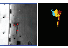
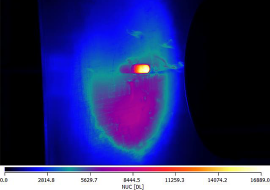
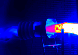
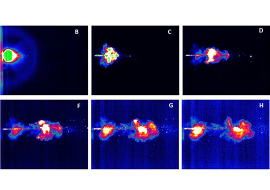
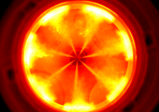
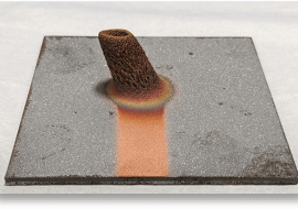
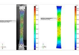
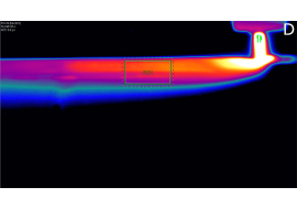
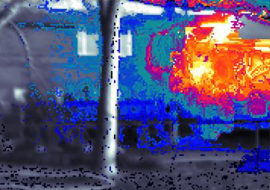
Telops high-speed infrared cameras are well-suited for capturing insightful data from battery research and development processes and assisting in furthering our understanding battery failure events. This is because Telops broadband and multispectral cameras provide the high frame rates and low noise equivalent temperature difference (NETD) necessary to capture the rapid, dynamic, and potentially destructive phenomena of battery deflagration. In the following application note we demonstrate the utility of our systems and their ability to gain valuable insights when deployed to image battery failure events caused thermal abuse and puncture.
Cold spray technology has attracted considerable attention in recent years as it has fully evolved from a conceptual theory to a practical application in industry. There are still many challenges with optimizing cold spray methodologies, but high-speed infrared imaging cameras offer rich information which is valuable to this process. Telops worked with the Canadian National Research Center (NRC) to test the capabilities of Telops’ multispectral cameras in monitoring multiple key processes during cold spray depositions. As opposed to previous cold spray measurements which only probed the temperature and speed of particles in flight, the NRC team seek to monitor the emissivity change of deposited layers on the substrate during the cold spray process. Time-resolved multispectral imaging illustrates the benefits of spectral information obtained at a high frame rate when facing dynamic situations such as this. The Telops MSM3K camera was used to fulfill these demanding requirements. In this note we present measurements demonstrating the possibility of performing complete in-process monitoring of the cold spray technique.
Methane emissions from biomass degradation at landfills are a significant contributor to environmental pollution and anthropogenic climate change. Methane is among the most infrared-active naturally occurring molecules and represents an 80X increase in atmospheric warming potency when compared to CO2. The need for reliable and cost-efficient methane detection technology is critical to mitigating the environmental damage caused by fugitive emissions.
Thermal infrared hyperspectral imaging is a powerful technology that allows for the detection, identification, and quantification of methane emissions from a wide variety of emissions sources. The Telops Hyper-Cam is a high capability thermal infrared hyperspectral imaging system that is suitable for the detection and quantification of both localized fugitive point-source emissions and diffuse methane emissions from a dispersed source. This webinar introduces Telops hyperspectral imaging technology and demonstrates its application to monitoring methane emissions.
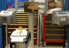
Active thermography was used as a multispectral non-destructive approach for characterisation of multi-layered panel paintings and analysis of their defects caused by aging and environmental effects. Two oil compositions painted on canvas, provided by C2RMF in the Louvre museum (Centre de Recherche et de Restauration des Musées de France) were under inspection. Active Thermography was demonstrated as being appropriate for characterization of various defects on painting layers and detection of under−drawings, pentimenti and canvas. Pulsed thermography system (PTvis setup of EDEVIS GmbH, provided by Thermoconcept) was applied to obtain and to inspect a dynamic thermal response, which was recorded by mid- and long-wavelength infrared TELOPS cameras. Control, synchronization and data analyses were made by EDEVIS DisplayImg Professional software (provided by Thermoconcept). In our studies, the combined approach provided by mid- and long-wavelength infrared cameras allowed us to obtain simultaneous complementary information on the painting specimen for its internal defects characterization and in situ inspection.
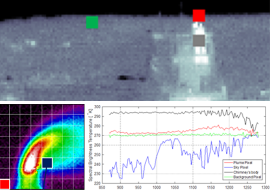
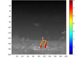
Muzzle flash analysis refers to the collection and exploitation of signatures generated by the expulsion of combustion gases from the muzzle produced during the discharge of a firearm. Muzzle flash characteristics are highly dependent upon attributes of both the firearm and ammunition including firearm make and model, barrel length, ammunition caliber and grain. Characterization of small arms muzzle flash is an important first step in the development of muzzle flash suppression systems, hostile small arms fire detection, and other critical defense technologies. Technical challenges for collection of muzzle flash signatures include the short duration of the flash (millisecond timescales) and its high variability in space and time. Imaging techniques are ideally suited for this type of analysis provided the spatial and temporal resolution are sufficient to capture the dynamics of the muzzle flash event. In this work, we present high-speed thermal infrared imaging data collected on muzzle flashes generated from a variety of small-arms configurations.
High temperature is a critical concern for most testing in the automotive, aerospace, and energy industries. Thermal expansion is an ever-present challenge, often making it difficult to distinguish strains caused from mechanical load from those originating solely due to material temperature change. Moreover, material deformation and its surface temperature change are strongly coupled because a significant part of the stress-energy used to induce the deformation is converted to heat. This has the effect of raising the material temperature and affecting the material deformation. Digital Image Correlation is the most efficient optical non-contact measurement method to measure strains. Since 2021, a productive Partnership between Telops and Trilion Quality Systems has led to the integration of Telops high-speed infrared cameras into ARAMIS Thermography solution for measurement of thermal and mechanical strains. This application note shows some results from this collaboration.
M. Gålfalk, S.N. Påledal, R. Sehlén, D. Bastviken.
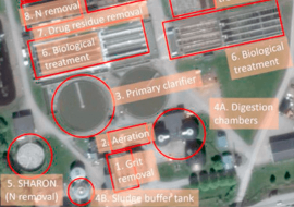
This study is an attempt to assess CH4 and N2O emissions from all the treatment steps of a wastewater treatment plant (WWTP) in Sweden, serving 145 000 persons, and an adjacent biogas production facility. We have used novel mid-IR ground-based remote sensing with a hyperspectral camera to visualize and quantify the emissions on 21 days during a year, with resulting yearly fluxes of 90.4 ± 4.3 tonne CH4/yr and 10.9 ± 1.3 tonne N2O/yr for the entire plant. The most highly emitting CH4 source was found to be sludge storage, which is seldom included in literature as in-situ methods are not suitable for measuring emissions extended over large surfaces, still contributing 90 % to the total CH4 emission in our case. The dominating N2O source was found to be a Stable High rate Ammonia Removal Over Nitrite reactor, contributing 89 % to the total N2O emissions. We also discovered several unexpected CH4 sources. Incomplete flaring of CH4 gave fluxes of at least 30 kg CH4/min, corresponding to plume concentrations of 2.5 %. Such highly episodic fluxes could double the plant-wide yearly emissions if they occur 2 days per year. From a distance of 250 m we found a leak in the biogas production facility, corresponding to 1.1 % of the CH4 produced, and that loading of organic material onto trucks from a biofertilizer storage tank contributed with high emissions during loading events. These results indicate that WWTP emissions globally may have been grossly underestimated and that it is essential to have effective methods that can measure all types of fluxes, and discover new potential sources, in order to make adequate priorities and to take effective actions to mitigate greenhouse gas emissions from WWTPs.
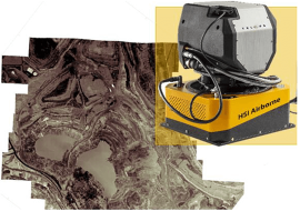
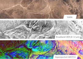
Minerals such as quartz, silicates, aluminosilicates (feldspar), magnesium silicates (serpentine) and olivines are among the most commonly encountered in the environment. Airborne mineral mapping of these minerals using conventional visible-near infrared (VNIR, 0.4-1.4 μm) and shortwave infrared (SWIR, 1.4-3 μm) sensors can be very challenging since the Si-O bounds are featureless or exhibit very weak spectral features in these spectral ranges. The fundamental vibrations associated with most functional groups composing the different ores mostly occurs in the thermal infrared (TIR, 8-12 μm) spectral range. In order to illustrate the benefits of thermal infrared hyperspectral imaging (HSI) with an instrument like the new Hyper-Cam Airborne Mini, two different case studies are presented.
The first will focus on an airborne survey carried out over an open-pit mine in the Thetford Mines (Qc, Canada) area. The results show how the high spectral resolution data provided by the Telops airborne system facilitates temperature emissivity separation (TES) and atmospheric correction in order to retrieve a thermodynamic temperature map of the area and its associated spectral emissivity datacube. Mineral mapping of various minerals such as lizardite, serpentinite and quartz was achieved through linear unmixing of the emissivity data using reference emissivity curves found in spectral libraries.
The second will illustrate how thermodynamic temperature maps of urban areas can be obtained after applying temperature-emissivity separation (TES) on the collected airborne thermal infrared hyperspectral imaging. In addition, a chemical map of quartz (SiO2), a material used in the fabrication of many buildings and roads, highlights the close association between UHI and man-made objects.
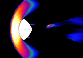
Infrared camera mounted on a fast trajectory tracker system was used to capture infrared imagery of a model space probe travelling at supersonic velocities. In addition to the laminar-to-turbulent transition boundary, the infrared camera was able to detect shock waves and present a time dependent view of the flow field. Readily available infrared technology has the capability to provide detailed visualization of various flow phenomena in subsonic to hypersonic flight regimes.
Scientists have developed several theoretical models to better understand and predict various aspects of wildfire behaviour. However, the lack of experimental data from real wildfire renders the validation of the models difficult and thus limits their applicability. More validation data would enable a better characterization of the valid boundaries within which the models can be applied. The Fire and Smoke Model Evaluation Experiment (FASMEE) aims at resolving this issue. “The Fire and Smoke Model Evaluation Experiment (FASMEE) is a large-scale interagency effort to identify how fuels, fire behavior, fire energy and meteorology interact to determine the dynamics of smoke plumes, the long-range transport of smoke and local fire effects such as soil heating and vegetative response.” FASMEE collects a wide of range of data from large prescribed fires by bringing together different instruments such as Light Detection and Ranging (LiDAR), radar, ground monitoring, aircraft and
satellite imagery, and weather and atmospheric measurements. More recently, a fast infrared camera was added to the list of instruments ready to deployed. This technology intends to cover four main study areas: fuels and consumption, fire behavior and energy, plume dynamics and meteorology, and smoke and emissions.
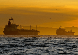
Sulfur oxide (SOx) from seagoing ships contribute to local air pollution in cities and coastal areas around the world. Sulfur dioxide (SO2) emissions in particular, are a precursor to acid rain and atmospheric particulates leading to ocean acidification which can contribute to negative human health outcomes. The International Convention for the Prevention of Pollution from Ships (MARPOL) defines limits on the sulfur content in ship fuel oils, since the sulfur is ultimately released into the atmosphere through the ship’s exhaust system as sulfur dioxide (SO2). This application note describes the use of remote hyperspectral imaging data collected using the Telops Hyper-Cam along with signal processing techniques to provide rapid and accurate estimation of sulfur content in fuel oils. Comparison between the retrieved sulfur content in the fuel of several ships with data from bunker delivery notes provided by the ship’s owner and in situ measurements performed by Transport Canada are presented.
R.D. Hewson et al.
Recent improvements and availability of optical to infrared to thermal satellite and airborne sensors opens up the opportunity for advancing surface mineralogy and geological mapping. Such mapping may include the identification of alteration zones for exploration activities or monitoring ore quality and inventory within open cuts. Remote sensing technology is also on the cusp of major new developments with deployment of hyperspectral sensor satellites, UAV/drones and proximal mine face sensors. Such imagery will provide additional compositional information within the geoscientists tool kit for regional to mine site scale studies. In particular the improvement and access of higher spectral and sometimes, spatial resolution will assist the mapping of different AlOH, MgOH, carbonate, sulphate and iron oxide mineral identities, potentially related to phyllic, propylitic and argillic alteration zones. Integration of such remote sensing map products with regional geophysical data and other geoscience information has in the past and will in the future refine and improve its interpretation. Satellite imagery and large-scale airborne survey acquisitions can be particularly useful for greenfields exploration in exposed terrain within arid to semi-arid remote areas. UAV/drone platform remote sensing is increasingly being applied to brownfields open cut observations and mine site environmental monitoring. However, an understanding of the caveats and limitations on remote sensing is essential. In particular, knowledge of the issues of sensor resolution, and illumination, atmospheric and ground conditions at the time of acquisition is important. This paper aims to provide a brief overview of current available remote sensing technologies, a cross section of related case studies, and a roadmap strategy for undertaking geological remote sensing applications.
The Telops Hyper-Cam Airborne Mini is a state-of-the-art thermal infrared hyperspectral imaging system designed for use on a wide-variety of manned and unmanned aerial platforms. Join Telops Field Application Engineer Benjamin Saute for a look at this latest entry to the Telops hyperspectral product line. This webinar serves as an introduction to the Hyper-Cam Airborne Mini, providing attendees with a detailed description of the hardware and underlying technology that make this product unique. Finally, we will show the Hyper-Cam Airborne Mini in action by highlighting key applications including gas detection, identification, and quantification, airborne geological exploration and mapping, and environmental research and compliance.
Methane emissions from industrial activities are a significant contributor to environmental pollution and anthropogenic climate change. Methane is among the most infrared-active naturally occurring molecules and represents a 25X increase in atmospheric warming potency when compared to CO2. Additionally, methane emissions represent a significant fire and explosion hazard within oil and gas and other industrial environments.
Thermal infrared hyperspectral imaging is a powerful technology that allows for the detection, identification, and quantification of methane emissions from a wide-variety of emissions sources. The Telops Hyper-Cam is a high capability thermal infrared hyperspectral imaging system that is suitable for the detection and quantification of both localized fugitive point-source emissions and diffuse methane emissions from a dispersed source. This webinar introduces Telops hyperspectral imaging technology and demonstrates its applications to a variety of methane emissions analysis scenarios.
Discover the brand-new Hyper-Cam Airborne Mini from Telops. At just over 50 pounds and with a volume of roughly one cubic foot, the Hyper-Cam Airborne Mini offers the best spectral resolution on the market, just like the regular Hyper-Cam – but in a compact and lightweight format engineered for aerial surveys.
Selectable spectral resolution down to 0.5 cm-1 and changeable fore-optics maximize measurement flexibility and ensure optimal ground coverage at all times.
EASY OF OPERATION The software continuously adapts system parameters to the everchanging flight conditions. A state-of-the-art active stabilization platform coupled with a re-engineered Image Motion Compensation system brings added mapping and targeting capabilities.
REAL-TIME DETECTION With an optional plug-in, the control and processing unit can even run powerful data analysis algorithms to present gas detection, identification, and quantification results in real-time. This allows the user to make fast and informed decisions.
Methane (CH4) and carbon dioxide (CO2) are landfill gases (LFG) originating from the decomposition of organic material as encountered in landfill areas. Both gases are considered greenhouse gases due to their high propensity for absorbing and emitting infrared radiation. For this reason, landfill installations are often equipped with wells and pumping systems to collect these LFGs. Depending on the quality of the gas mixture, the LFGs may be collected, flared, or simply dispersed in the atmosphere through passive methane vents. In some situations, gas leaks may occur directly on-site at the landfill originating from components such as the wells, tubing system, or a degraded landfill liner. In the case where lateral migration occurs, the gas leaks may even originate on properties located in the landfills’ neighborhood. These situations are difficult to address since they require surveillance over large areas. Several gas measurement techniques are currently available. Gas sampling using pressurized canister vessels or bags provides accurate results, even at low concentrations, but is time consuming since the samples need to be taken into a lab for analysis. Electrochemical cell sensors, also known as gas sniffers, provide accurate real-time results. Conventional gas measurement techniques typically provide single-point results and are not well suited for the localization of an unknown gas leak within a large area. In order to illustrate how thermal infrared hyperspectral imaging performs in landfill environments, results from measurements of diffuse methane emissions are presented. Real-time chemical imaging results, carried out on a passive methane vent, are also presented. The results illustrate how thermal infrared hyperspectral imaging systems provide valuable information to survey methane gas in landfill areas.
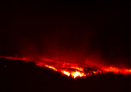
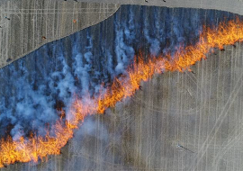
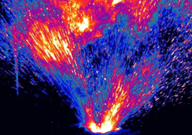
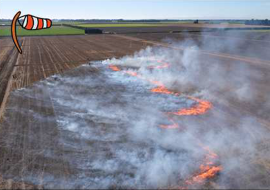
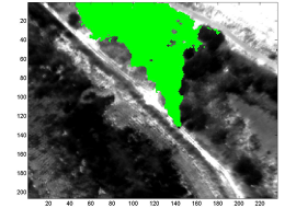
Wildfire spreads by pre-heating unburnt fuels (vegetation) using a combination of radiative and convective heating processes. In rapidly spreading grass or stubble wheat fuels, turbulent wind flow aids to intermittently convect the heat produced by combustion onto the unburnt fuels leading to its ignition and fire spread. In a way, the fire is sustaining its motion, but the role of atmospheric turbulence, its intensity, and scale is a fundamental player in the unpredictability of fire spread. In order to better understand the generated turbulences, a Telops infrared camera was used to capture images of a controlled stubble wheat burn from an elevated position.
Eitan Hirsch, Eyal Agassi, Alon Manor.
Quantitative real-time retrieval of concentration-lengths (CL) through gaseous plumes is an important tool for environmental monitoring, enabling remote monitoring of emissions from industrial facilities and risk assessment
in scenarios of toxic gas releases. The adoption of LWIR (Long Wave Infra-Red) hyperspectral imaging as a leading technique for remote gas plume detection paved the way for an introduction of a precise CL estimation and two-dimensional (2D) mapping. A novel methodology for evaluating and characterizing the performance of a retrieval algorithm is presented. The algorithm utilizes state-of-the-art retrieved hyperspectral 2D mapping and is applied on a series of localized atmospheric tracer gas (SF6) releases in monitored environmental conditions. The retrieved CL distributions are compared to a numeric atmospheric T&D (Transport and Diffusion) model. Satisfactory agreement between retrieved and simulated CL prediction is manifested, and the uncertainty involved is quantified. Possible sources for the remained discrepancies between retrieved and simulated CL values are characterized, and methods to minimize them are discussed.
F. Coussa, J. Berthe, M. Ragonet.
In this study, the rate dependency of transverse cracking evolution in cross-ply laminates is investigated for several 90° plies thicknesses. The crack detection methodology is based on a recently proposed protocol relying on the use of infrared thermography. A new analysis methodology is proposed to make it more robust and to directly link the spatial localization of the crack with the stress level at which it occurs. Based on this methodology, the results obtained for various loading rates and 90° ply thicknesses are analysed. The crack density evolution with respect to stress apply to the laminate exhibits a rate dependency only for the [0/90]s configuration. This rate dependency is finally discussed based on transverse crack onset theories in cross-ply laminates.
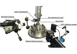
G.C. Soares, N.I. Vázquez-Fernández, M. Hokka
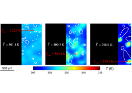
Despite tensile testing being commonly used for investigating the mechanical behavior of materials, the occurrence of heterogeneous strain and increasing temperature at high strain rates make the experiment much more complex. This work presents a method integrating synchronous full-field stereo Digital Image Correlation (DIC) and Infrared Thermography (IRT). This method enabled high resolution investigations of the development of local temperatures and strains of the specimen during tensile loading of four steels at strain rates ranging from 2.5·10−4 to 900 s−1. The tests were monitored by a stereo setup of optical cameras and an infrared camera. Data acquisition was synchronized, and a pinhole camera model was used to translate the images from all cameras to the same three-dimensional space. The displacement vector fields from DIC were subtracted from the IRT images to represent the temperature maps in a Lagrangian coordinate system. The overall thermomechanical response of the materials was shown as 3D waterfall plots, which represent localized strain and temperature as a function of position and engineering strain. The results show that temperature increased homogeneously during uniform deformation at higher strain rates (10−2-900 s−1) and increased markedly with the onset of necking on the region of localized strain. At these strain rates, the localized increase of strain and temperature during necking were observed at the same global engineering strain and position, evidencing the spatial and temporal synchronization. The described method was used to accurately investigate the evolution of
localized strain and temperature in both low and high strain rate regime.

The extraction of both velocity and temperature of particles during the cold spray (CS) process using a high-speed, high-definition infrared (IR) camera was demonstrated by Nastic, A. & Jodoin, B.1. Following the success of this project, Telops worked with the University of Ottawa to address the challenges of measuring the speeds and temperatures of smaller cold spray particles (as small as 40 microns in diameter) made of aluminum and copper (more reflective materials) traveling at much greater speeds (in excess of 600 m/s) in low flow regimes (~2 g / min). In order to measure such small and ultra-fast particles, imaging data was acquired using the Telops M350 high-speed thermal camera operating in the 1.5 μm to 5.4 μm spectrum.
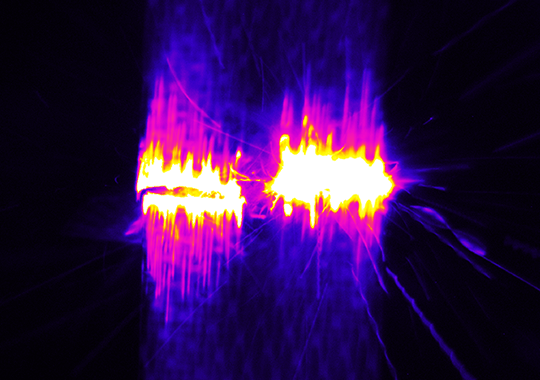
The measurement of physical properties of expanding gases in the infrared region following a high-explosive detonation requires cameras having both high framerate and fine spectral resolution. Moreover, an accurate gas model is required to adequately explain and quantify the rapidly-evolving events based on properly-interpreted gas emissivity signatures. To achieve this goal, a Telops MW Fast-M350 high-speed broad-band camera and a Hyper-Cam-MWE hyperspectral camera were used to capture such energetic, fast-changing events.
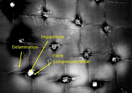
In this study, we investigated the assessment of the damaged area on composites ballistic plates subjected to high velocity impact. The active pulsed thermography technique was used for performing post-mortem analysis of the impacted specimens. Quantitative analysis of the damaged areas shows consistent results with the size of the projectile suggesting high precision of the quantification done in this work. This quantitative defect analysis combined with knowledge of projectile velocity allows for characterization of absorbed energy and differentiation of generated defect types. This allow for the evaluation of material efficiency in spreading absorbed energy over large areas. Our observations indicate that high velocity shots tend to induce smaller impact damage areas characterized primarily by fiber breakage, while low velocity shots tend to induce larger impact damage areas featuring predominantly delamination and matrix cracking damage mechanisms.
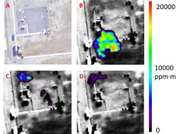
Gas leaks present obvious health, safety and environmental risks. In oil and gas companies for instance, constant monitoring is crucial to preserve on-site personnel security and to prevent damage to the installations. The need for a reliable and cost-efficient gas detection system is of prime importance especially when security-threatening situations like gas leaks and emissions occur. Precise localization of the leaks, identification of the chemical nature of the gases involved, and quantification of the gas flux emanating from the leaks may help the incident response team to take actions based on relevant information. In this regard, infrared remote sensing technology offers many benefits over traditional gas detection systems as it allows monitoring and imaging of the incident scene from a safe location. The sensor can be located at distances ranging from tens of meters to several kilometers from the scene, avoiding the need to access restricted and potentially dangerous zones in the installations. Passive infrared hyperspectral imaging technologies are among the solutions that can efficiently and safely address gas leaks. Telops has developed hyperspectral imaging solutions for gas detection and identification along with tools for the quantification of gas flow rates emanating from the leak source. These solutions were recently used during a controlled methane release test campaign carried out at National Physical Laboratory in UK. The results presented in this application note show the potential of Telops gas detection and quantification solutions for real time visualisation of methane and its dynamic dispersion within production plants.
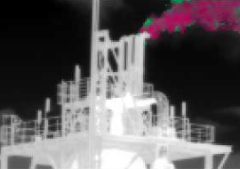
Safety is a major concern for oil and gas companies as chemicals encountered in their installations can be toxic or presentSafety is a major concern for oil and gas companies as chemicals encountered in their installations can be toxic or presenta high explosion potential. A reliable gas identification and quantification imaging system represents an upgrade to thecurrent gas detection technologies for monitoring the evolution of hazardous conditions. Infrared imaging can visualizefugitive emissions and gas leaks under various environmental conditions and industrial contexts. Efficient gas detectionand quantification from a remote location is advantageous for safety purposes as gases like methane or natural gas (CH4)are flammable. Considering the potential size of the plume in the case of a major leak and the remoteness of the site,aerial operation is desirable. This application note presents how the Telops Hyper-Cam airborne provides valuable gasdetection, identification, and quantification information. To illustrate the potential of this system, recent results obtainedduring a series of controlled methane releases operated by Total on their Test Pilot Platform in Lacq, France are presented.
Thermal infrared hyperspectral imaging is well suited for the detection, identification, and quantification of industrial stack gas emissions. This application note describes a measurement campaign performed at the Port of Rotterdam with the Telops Hyper-Cam, a commercial high-performance, FTIR-based hyperspectral imaging instrument. Principles of gas detection, quantification, and identification are discussed and computed mass-flow rate results are presented from data acquired at a commercial alkene production facility.
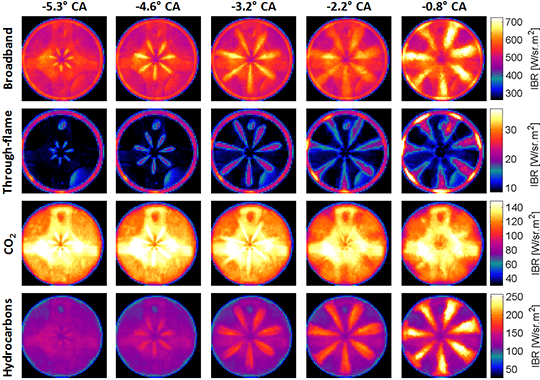
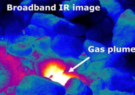
Volcanic carbon dioxide (CO2) emission rates play an important role for assessing volcanic hazards and for constraining the role of magma degassing in the biogeochemical cycle of carbon. Quantification of CO2 emission rates from volcanoes remain challenging, mainly due to the difficulty of measuring volcanic CO2 against the high level of CO2 in the atmosphere. Thermal Infrared (TIR) imaging is now a well-established tool for the monitoring of volcanic activity, since many volcanic gases such as CO2 and sulphur dioxide (SO2) are infrared-active molecules. High speed broadband cameras give valuable insight into the physical processes taking place during volcanic activity, while spectrally resolved cameras are able to assess the chemical composition of volcanic gases. Over the years, Telops has developed a variety of high-performance, spectrally resolved infrared imaging tools including hyperspectral imaging systems based on Fourier Transform Infrared technology and time-resolved multispectral imaging systems enabled by detector synchronization with a fast-rotating spectral filter wheel. The current work presents the results of a multispectral infrared imaging measurement campaign performed at the Sulphur Banks from Kilauea Volcano. The Sulphur Banks area is well known for continuous low-level emissions of volcanic gases including carbon dioxide, sulfur dioxide, and hydrogen sulfide. Multispectral imaging data was acquired at relatively high spatial resolution through a variety of spectral bandpass filters, leading to the successful identification and quantification of emitted carbon dioxide.
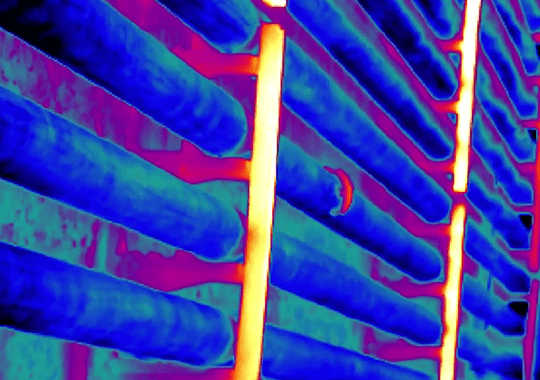
Thermal infrared imaging technology is well suited to monitoring the spatially-varying temperature gradients induced in fabricated metal parts during high-temperature welding processes. This application note demonstrates how Telops multispectral thermal infrared cameras can be used to monitor important welding process characteristics like melt pool geometry and local heating and cooling gradients.
Wildfire physics has traditionally been studied through intensive modelling that requires numerous assumptions of combustion and heat transfer (Sullivan 2009) adapted from established structure-fire engineering relations. Renewed emphasis in experimental research has caused rethinking of some of the most basic concepts in wildland fuel particle ignition and flame spread. New findings from laboratory experiments conducted by the U.S. Forest Service’s Missoula Fire Sciences Lab reveal the source of convective heating in spreading fires derives from fire-induced vorticity, which forces flames downward and ahead of the combustion zone in intermittent contact with fuel particles (Finney et al. 2015). New laboratory techniques capture the intermittency and suggest it has predictable average frequencies familiar in studies of buoyant instabilities. The scaling relations for wind and buoyancy have shown promise at field scales but need to be further tested.
H. Grant Pearce, Mark Finney, Tara Strand, Marwan Katurji and Craig Clements. New Zealand field-scale fire experiments to test convective heat transfer in wildland fires.
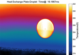
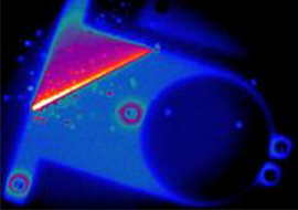
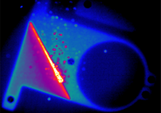
Over the past few years, two-color pyrometry has proven to be a fast and reliable non-invasive method to accurately determine the temperature of materials by overcoming emissivity issues usually encountered by thermal infrared cameras. However, the need for multiple independent cameras makes this method expensive to implement. In this work, a single Telops MS M100k equipped with a fast-rotating spectral filter wheel was used to accurately determine the temperature of a steel plate attacked by a kerosene flame. Experimental temperatures determined using this method were compared against thermocouple reference measurements for method validation.
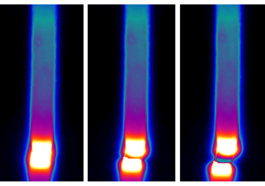
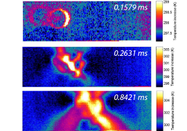
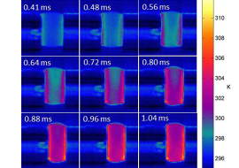
The enormous progress made in the three last decades in high-speed thermal imaging have given rise to a wide variety of applications, of which material testing is maybe one of the most prominent. Split-Hopkinson bar experiments can especially benefit from the development of high-speed and high-resolution thermal infrared imaging. When materials are subjected to mechanical stress, rapid changes in the structure can occur. Being able to monitor hot spots prior to the breaking can help in the characterization of new material. In the present work, we have carried out high-speed infrared imaging at 20 000 frames per second (fps) during split-Hopkinson pressure bar experiments on graphite-fiber and epoxy composite materials to observe hot-spot formation and crack initiation. The results illustrate how high-speed infrared imaging can provide detailed information on the thermal properties of materials undergoing mechanical testing.
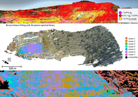
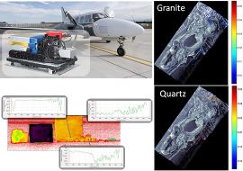
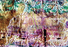
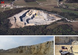
Remote sensing systems are largely used in geology for regional mapping of mineralogy and lithology mainly from airborne or spaceborne platforms. Earth observers such as Landsat, ASTER or SPOT are equipped with multispectral sensors, but suffer from relatively poor spectral resolution. By comparison, the existing airborne and spaceborne hyperspectral systems are capable of acquiring imagery from relatively narrow spectral bands, beneficial for detailed analysis of geological remote sensing data. However, for vertical exposures, those platforms are inadequate options since their poor spatial resolutions (metres to tens of metres) and NADIR viewing perspective are unsuitable for detailed field studies.
Here, we have demonstrated that field-based approaches that incorporate thermal infrared hyperspectral technology with about a 40-nm bandwidth spectral resolution and tens of centimetres of spatial resolution allow for efficient mapping of the mineralogy and lithology of vertical cliff sections. We used the Telops lightweight and compact passive thermal infrared hyperspectral research instrument for field measurements in the Jura Cement carbonate quarry, Switzerland. The obtained hyperspectral data were analysed using temperature emissivity separation algorithms to isolate the different contributions of self-emission and reflection associated with different carbonate minerals. The mineralogical maps derived from measurements were found to be consistent with the expected carbonate results of the quarry mineralogy. Our proposed approach highlights the benefits of this type of field-based lightweight hyperspectral instruments for routine field applications such as in mining, engineering, forestry or archaeology
Boubanga-Tombet, S.; Huot, A.; Vitins, I.; Heuberger, S.; Veuve, C.; Eisele, A.; Hewson, R.; Guyot, E.; Marcotte, F.; Chamberland, M. Thermal Infrared Hyperspectral Imaging for Mineralogy Mapping of a Mine Face. Remote Sens. 2018, 10, 1518.
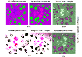
Continuum removal is vital in hyperspectral image analysis. It enables data to be used for any application and usually requires approximations or assumptions to be made. One of these approximations is related to the calculation of the spectra of the background’s blackbody temperature. Here, we present a new method to calculate the continuum removal process. The proposed method eliminates the calculation for ground-based hyperspectral infrared imagery by applying two acquisition sets before and after using the heating source. The approach involves a laboratory experiment on a long-wave infrared (7.7mm to 11.8mm – LWIR), with a LWIR-macro lens, an Infragold plate and a heating source. To calculate the continuum removal process, the approach applies nonnegative matrix factorization (NMF) to extract Rank-1 NMF, estimate the downwelling radiance and compare it with that of other conventional methods. NMF uses gradient-descent-based rules (GD) and non-negative least squares (NNLS) optimization algorithms to obtain Rank-1 NMF. A comparative analysis is performed with 1%˘20% additive noise for all algorithms by using the spectral angle mapper and normalized cross correlation (NCC). Results reveal the promising performance of NMF-GD (average of 72.5% similarity percentage using NCC) and NMF-NNLS (average of 77.6% similarity percentage using NCC).
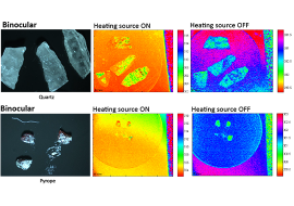
The developments in hyperspectral technology in different applications are known in many fields particularly in remote sensing, airborne imagery, mineral identi- fication and core logging. The automatic mineral identification system provides considerable assistance in geology to identify mineral automatically. Here, the proposed approach addresses an automated system for mineral (i.e. pyrope, olivine, quartz) identification in the long-wave infrared (7.7µm to 11.8µm – LWIR) ground-based spectroscopy. A low-rank Sparse Principal Component Analysis (Sparse-PCA) based spectral comparison methods such as Spectral An- gle Mapper (SAM), Spectral Information Divergence (SID), Normalized Cross Correlation (NCC) have been used to extract the features in the form of colors composite. Low-rank Sparse-PCA is used to extract the spectral refer- ence which and showed high similarity to the ASTER (JPL/NASA) spectral library. For decision making step, two methods used to establish a comparison between a kernel Extreme Learning Machine (ELM) and Principal Component Analysis (PCA) kernel K-means clustering. ELM yields classification accuracy up to 76.69% using SAM based polynomial kernel ELM for pyrope mixture, and 70.95% using SAM based sigmoid kernel ELM for olivine mixture. This accuracy is slightly lower as compared to clustering which yields an identifi- cation accuracy of 84.91% (NCC) and 69.9% (SAM). However, the supervised classification significantly depends on the number of training samples and is considerably more difficult as compared to clustering due to labeling and train- ing limitations. Moreover, the results indicate considerable similarity between the spectra from low rank approximation from the spectra of pure sample and the spectra from the ASTER spectral library.
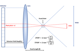
A field campaign. A laboratory testbed. A volcano. Different applications of infrared cameras, but the very same modus operandi. Turn the camera on, point it toward the scene, and get images on the screen. It looks so simple! And the image is even calibrated in real temperature units. Great!
Real life conditions are unfortunately a bit more complex. Accurate interpretation of the infrared images may be achieved, but it requires a good knowledge of the measurement conditions along with some radiometry skills. The goal of the present note is to describe how simple scene models may be established, how their limitations are determined, and how can we use them to estimate physical parameters like the thermodynamic temperature of the objects we are looking at.
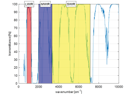
This technical note is divided into 2 parts. The first one deals with the most important effect a camera user is faced with: the object emissivity. In the second, we discuss the contribution of the semi-transparent atmosphere through which the object is observed.
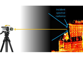
What is radiometry? The etymology of radiometry links to “radiation” and “measurement”. More precisely, radiometry is the science studying the transport of energy through radiation.
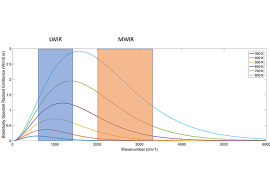
The present document aims at presenting a summary of the principal laws of radiometry involved in the understanding of the world surrounding us, as seen through light-sensitive instruments! Among these are the main Telops products in infrared measurement: broadband cameras (with neutral/spectral filters) and high-spectral-resolution imaging spectrometers.
This technical note is divided into three parts. The first one deals with basic definitions provided by electromagnetics. The second introduces the main physical quantities involved in radiometry. Finally, the document concludes by describing the mechanisms of interaction between radiation and matter.
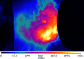
Additive manufacturing, also known as 3D printing, is considered by many to be the biggest industrial revolution since the Internet. This method allows rapid fabrication of metal pieces with various compositions, shapes and sizes. However, the extremely high thermal gradients involved in this fabrication process can induce stress and deformation in the materials. In an effort to better understand and vizualize these thermal transfers, high-speed infrared imaging of the Direct Metal Laser Sintering (DMLS) process on stainless steel was carried out at 2800 frames per second (fps) with the Telops FAST M2k infrared camera at the Centre de recherche industrielle du Québec (CRIQ). The results illustrate how high-speed infrared imaging can provide detailed information about thermal transfers in metal parts during the additive manufacturing process.
High-speed infrared imaging provides new insights for research on additive manufacturing. Fundamental research on heat transfers and monitoring of the printing process can benefit from high spatial, thermal and temporal resolutions.
It is now possible to collect hyperspectral video sequences at a near real-time frame rate. The wealth of spectral, spatial, and temporal information of those sequences is appealing for various applications, but classical video processing techniques must be adapted to handle the high dimensionality and huge size of the data to process. In this paper, we introduce a novel method based on the hierarchical analysis of hyperspectral video sequences to perform object tracking. This latter operation is tackled as a sequential object detection process, conducted on the hierarchical representation of the hyperspectral video frames. We apply the proposed methodology to the chemical gas plume tracking scenario and compare its performances with state-ofthe-art methods, for two real hyperspectral video sequences, and show that the proposed approach performs at least equally well.
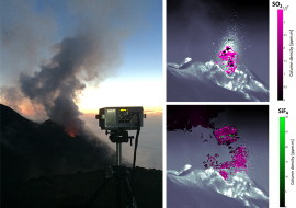
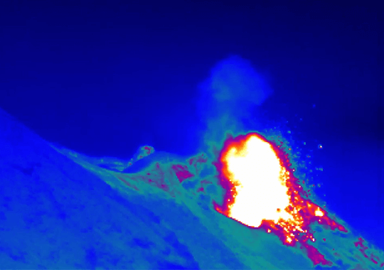
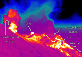
Many urban areas are located near active volcanoes around the world. Therefore, scientific research on different indicators of imminent eruptions is carried out on an ongoing basis. Due to the hazardous and unpredictable behavior of volcanoes, remote sensing technologies are normally preferred for investigations. Over the years, the Telops Hyper-Cam, a high-performance infrared hyperspectral camera, has established itself as a reference tool for investigating gas clouds over large distances. In order to illustrate the benefits of standoff infrared hyperspectral imaging for characterizing volcanic processes, many different measurements were carried out from an elevated point of the Stromboli volcano (Italy) by researchers from the Université Blaise-Pascal (Clermont-Ferrand, France).
The Stromboli volcano is well known for its periodic eruptions of small magnitude containing various proportions of ash, lava and gases. Imaging was carried out at a relatively high spectral and spatial resolution before and during eruptions from the North-East crater. Both sulfur dioxide (SO2) and silicon tetrafluoride (SiF4) could be successfully identified within the volcano’s plume from their distinct spectral features. Quantitative chemical maps for both gases are presented in this work. The results show that standoff thermal infrared hyperspectral imaging provides unique insights for a better understanding of volcanic eruptions.
Heat transfers are involved in many phenomena such as friction, tensile stress, shear stress and material rupture. Among the challenges encountered during the characterization of such thermal patterns is the need for both high spatial and temporal resolution. Infrared imaging provides information about surface temperature that can be attributed to the stress response of the material and breaking of chemical bounds.
In order to illustrate this concept, high-speed infrared imaging was carried out at 13 000 frames per second during a split-Hopkinson pressure bar experiment on a polymer sample at the Structural Impact Laboratory (SIMLab) of the Norwegian University of Science and Technology. The results illustrate how high-speed infrared imaging can provide detailed information about the thermal properties of materials undergoing mechanical testing.
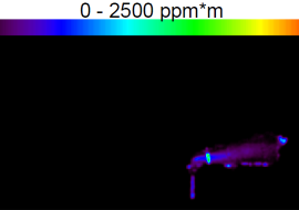
There are many types of natural gas fields including shale formations that are common especially in the St-Lawrence Valley (Canada). Since methane (CH4), the major component of shale gas, is odorless, colorless and highly flammable, in addition to being a greenhouse gas, methane emanations and/or leaks are important to consider for both safety and environmental reasons.
Telops recently launched on the market the Hyper-Cam Methane, a field-deployable thermal infrared hyperspectral camera specially tuned for detecting methane infrared spectral features under ambient conditions and over large distances.
In order to illustrate the benefits of this novel research instrument for natural gas imaging, the instrument was brought on a site where shale gas leaks unexpectedly happened during a geological survey near the Enfant-Jesus hospital in Quebec City, Canada, during December 2014. Quantitative methane imaging was carried out based on methane’s unique infrared spectral signature. Optical flow analysis was also carried out on the data to estimate the methane mass flow rate. The results show how this novel technique could be used for advanced research on shale gases.
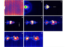
The thermal hyperspectral sensor Hyper-Cam was mounted on a light aircraft and measured continuous releases of several atmospheric tracers from a height of 2 km. A unique detection algorithm that eliminates the need for clear background estimation was operated over the acquired data with excellent detection results. The data-cubes were acquired in a “target mode”, which is a unique method of operation of the Hyper-Cam sensor. This method provides multiple views of the plume which can be exploited to enhance the detection performance. These encouraging results demonstrate the utility of airborne LWIR hyperspectral imaging for efficient detection and mapping of effluent gases for environmental monitoring.
Copyright 2016 Society of Photo Optical Instrumentation Engineers. One print or electronic copy may be made for personal use only. Systematic reproduction and distribution, duplication of any material in this paper for a fee or for commercial purposes, or modification of the content of the paper are prohibited.
Proc. SPIE 9824, Chemical, Biological, Radiological, Nuclear, and Explosives (CBRNE) Sensing XVII, 98240U (May 12, 2016); doi:10.1117/12.2222142
Hyperspectral imaging in the long-wave infrared (LWIR) is a mean that is proving its worth in the characterization of gaseous effluent. Indeed the spectral and spatial resolution of acquisition instruments is steadily decreasing, making the gases characterization increasingly easy in the LWIR domain. The majority of literature algorithms exploit the plume contribution to the radiance corresponding to the difference of radiance between the plume-present and plume-absent pixels. Nevertheless, the off-plume radiance is unobservable using a single image.
In this paper, we propose a new method to retrieve trace gas concentration from airborne infrared hyperspectral data. More particularly the outlined method improves the existing background radiance estimation approach to deal with heterogeneous scenes corresponding to industrial scenes. It consists in performing a classification of the scene and then applying a principal components analysis based method to estimate the background radiance on each cluster stemming from the classification.
In order to determine the contribution of the classification to the background radiance estimation, we compared the two approaches on synthetic data and Telops Fourier Transform Spectrometer (FTS) Imaging Hyper-Cam LW airborne acquisition above ethylene release. We finally show ethylene retrieved concentration map and estimate flow rate of the ethylene release.